GIS/Maps
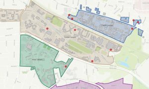
A Geographic Information System (GIS) utilizes numerous computer-based tools to store, create, manage, analyze, and visualize geographic or spatial data on a map. The NC State Enterprise GIS group, housed within Campus Planning and Strategic Investment, maintains and updates a central repository of GIS data and maps for Facilities as well as other departments and groups at NC State. Understanding the geographical context of our physical campus space and assets allows us to inform our community, identify the needs of our campus, support operations, and more. Check out our Story Map to learn more about what we do with Enterprise GIS or visit our GIS Portal view some of our mapping applications.
CONTACT:
Laurel Krynock, GIS Administrator, lwkrynoc@ncsu.edu
Dave Wynne, GIS Project Manager, dswynne@ncsu.edu
Matt Laska, GIS Analyst, mrlaska@ncsu.edu
Campus Map

NC State University Campus Map
Printable Map Downloads
Use your browser’s download function to save to your local disk to view the complete PDF.
Campus Map and Directory (11×17 PDF)
Campus Map (42×42 PDF)
Campus Map – Accessibility (92×92 PDF)
Campus Map – including Lake Wheeler and Reedy Creek (30 x 42 PDF)
GIS Data Downloads
The files have been compressed using a zip utility and can be downloaded by clicking on the file name, saving to your local disk, and unzipping.
Building Footprints (shapefile)
Campus Perimeters (shapefile)
includes Central, Centennial, North, South, and West precincts, the Reedy Creek and Lake Wheeler field labs, as well as Outlying areas.
Campus Existing CAD Map (AutoCAD file)
Additional Resources

Download GIS Data Standards
GIS Data Collection Standards and Geospatial Data Standards | Revised February 2024

Enterprise GIS Steering Committee
Information about committee members, meetings, and more.
Disclaimer
NC State University makes every effort to produce and publish the most current and accurate content possible. However, the maps and data are produced for informational purposes and are NOT surveys. The information is compiled from various sources and not intended for official use or legal reference. The user of this site should not solely rely on the data provided herein. The information provided may not be used for commercial purposes or sold.
