Campus History
The Physical Development of NC State University
 Few if any of NC State’s founders foresaw the growth that the university has experienced. Early design efforts focused on a much smaller campus than today’s twenty-one hundred acres and over 14.7 million gross square feet of built space accommodating a community of over forty-five thousand people. And history intervened in ways that often focused planning on near-term rather than long-term needs. Many of the Courtyards, Open Spaces, and walkways in the older sections of the campus appear to have been part of an original intention but in fact were nurtured and developed piece by piece over the years.
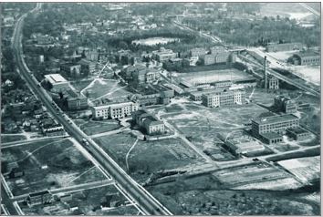
From the university’s pastoral beginning along Pullen Road, enrollment and facilities grew steadily and moderately until the end of the First World War, after which they accelerated. Plans of the 1920s called for grouping buildings that housed like activities, such as the agriculture and engineering groupings on the North Campus, classrooms around the Court of North Carolina, the university administration near Holladay Hall, athletics around Riddick Stadium, and student residence halls south of the railroad.
During the Great Depression, the university lost several graduate programs, and its progress was in jeopardy. Planning for expansive growth was not a priority. After the Second World War, however, enrollment surged, many graduate and research programs were restored or started, and the university embarked on an optimistic course of growth that continues to the present.
NC State’s first postwar physical master plan was created in 1958, the same year the university’s first modern long-range strategic plan was written. The physical master plan brought some coherence to a burgeoning campus, but while it was meant to help the university achieve other strategic long-range goals, it did not become a formal part of the strategic planning process. Adherence to the master plan was desirable but not mandatory.
The 1958 plan divided academic activity from student activity into North and South Campuses, respectively. It established a central pedestrian area (University Plaza), suggested moving vehicular traffic to the campus’ periphery, and dispersed some new construction into all areas of a six-hundred-acre campus.
In 1960 the university established the Campus Planning Office, which updated the 1958 plan. It defined a compact, high-rise, pedestrian-scaled campus with all essential services within a ten-minute walking radius. The plan for the university’s urban center was thus established.
In 1963, several points of the 1958 plan were reemphasized, including zoning of the academic campus around D. H. Hill Library and focusing student activities on a new South Campus student center and gymnasium.
“Campus Environment and Planning System,” a 1968 in-house report, endorsed the compact campus center but also suggested some decentralization through dispersal of activities. This marked the emergence of the idea that the campus could be a group of neighborhoods. The university was growing into an academic town parallel to Raleigh’s growth into a mid-size city.
As the decentralization of some activities started, campus planners also began to set aside open spaces around which clusters of buildings could be grouped and around which pedestrian and vehicular traffic could be directed. That concept was formalized in 1975 when “A Framework of Courtyards” proposed that the campus be viewed, and in the future be developed, as a system of interconnecting neighborhoods. Because of the university’s continued growth, decentralization had become a fact of life as the campus expanded beyond the compact core. The open space network emerged as a means of giving coherence and unity to the campus.
The 1978 Physical Master Plan reemphasized the importance of courtyards and connectors to campus design and, for planning purposes, divided the growing campus into a series of precincts, based on the integration of geography and land use.
In 1982, the system of interconnected courtyards, with accompanying strategies for traffic flow, was used in the siting of new buildings. Decentralization continued, with substantial infill. The concept of decentralization with interconnection was reemphasized in the 1983 “Space Inventory and Potential” report that focused heavily on the development of the university’s satellite areas as well as the core campus.
When in 1984 the university announced its intention to build Centennial Campus on the state’s initial allocation of 385 acres of land from the Dorothea Dix Hospital property, immediately south of the original campus, it created a unique planning opportunity. Centennial Campus, unlike the original campus, would have the benefit of a far-reaching master plan from the start.
The Centennial Campus Master Plan, approved by the Board of Trustees in 1987, and its accompanying Design Guidelines formalized principles that had emerged on the original campus. The new campus would be composed of “related villages, neighborhoods and courtyards – each a distinctive place whose character is defined by a multi-approach architecture that provides life and animation and is connected to the site’s natural landscape. The campus composition intends to be a fabric with emphasis on the spaces between the buildings rather than on individual buildings.”
By formalizing the concepts that had emerged organically from the development of the original campus, the Centennial Campus plan guidelines laid the foundation for the 1994 Physical Master Plan. Both called for the integration of institutional activities into Mixed-Use communities. The high quality of the development on Centennial Campus from its inception to the present represents the efficacy of the concepts and guidelines that were formally applied to the entire campus with the 1994 plan. These have shaped substantial new building efforts not only by the university but also by public and private partners who have benefited by utilizing the planning standards. Centennial Campus emerged as an exemplary model of a Mixed-Use academic and research campus.
It was with the 1994 plan that the term Campus Neighborhood entered the vocabulary of the wider campus community. The subsequent 2000 master plan, A Campus of Neighborhoods and Paths had grown directly from and was built on the 1994 plan via a campus-wide planning process. In 1997, Chancellor Larry Monteith initiated a workshop process for North Campus that focused particularly on two large spaces with development potential: the Riddick Stadium parking area and the land occupied by the North Campus greenhouses. The North Campus Workshop produced specific plans for the new Fox Science Teaching Laboratory and, perhaps even more important, established a collaborative model for campus planning. This model was used in five additional workshops covering the remaining campus precincts. All workshops were chaired by Smedes York, chair of the Trustees’ Buildings and Property Committee, and attended by a broad cross section of stakeholders representing the precinct and community. The precincts, which had become the focus of campus development in the 1978 master plan, remain a useful division of the campus, and much infrastructure development and wayfinding is still based on existing precinct plans. Designers and planners continue to use many maps that divide the campus into precincts, and reference can be found to them in numerous planning documents. The concepts of Campus Neighborhoods and Campus Paths rather than precincts, however, determine the character of the NC State Campus.
The precinct workshops became the basis for updating the 1994 master plan, and a significant theme arose from them – a clear demand for a more beautiful campus, one enlivened with more green space and oriented toward pedestrians. Participants also voiced overwhelming support for transportation alternatives, including the Triangle Transit Authority’s proposed regional rail system and the envisioned campus people-mover system. Additionally, with the decision in 1997 to move the College of Engineering to Centennial Campus came the need to plan for other facilities such as housing and dining to support the significant number of undergraduate students in the college. When work on A Campus of Neighborhoods and Paths started in 1998, these ideas became important principles.
As the precinct workshops and the revision of the master plan were underway, other significant physical planning events occurred that have had an effect on A Campus of Neighborhoods and Paths and the way it will be implemented. The Board of Trustees established the Campus Design Review Panel to guide design decisions. The workshops produced new partnerships through the community collaboration. The Hillsborough Street Partnership created a vision for a quintessential city-university interface, and today the street continues to be revitalized through investments in the streetscape.
In the late 1990’s, the planning process was influenced by an increased role played by University of North Carolina – General Administration (UNC-GA) as space standards and repair and renovation formulas were established. A 1999 system-wide report identified substantial facility needs, which were included in a ten-year capital improvements plan. The incorporation in the 2000 master plan of the Capital Improvement Plan tied the vision of a memorable campus to the concrete programmatic demands of a growing institution.
On November 7, 2000 the voters of North Carolina approved a higher education bond referendum, which funded $473 million of capital projects that added more than 1.3 million square feet of new space and renovated more than 900,000 square feet of existing space between 2000 and 2009. Also during this timeframe, an additional $725 million of non-bond funded projects were planned and constructed, renovating facilities, adding new buildings, and providing infrastructure. NC State was poised and ready for this period of rapid growth, in part due to the Guiding Principles, planning concepts, and priorities developed with the 2000 edition of A Campus of Neighborhoods and Paths.